Products
Our products package years of development into purpose-built solutions for the defense software industry. Customized, adaptive and continually enhanced through fast working partnerships, each product delivers a unique capability.
We can tell you about our products, but we would rather show you.
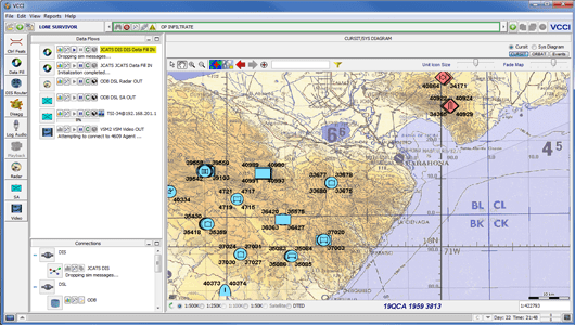
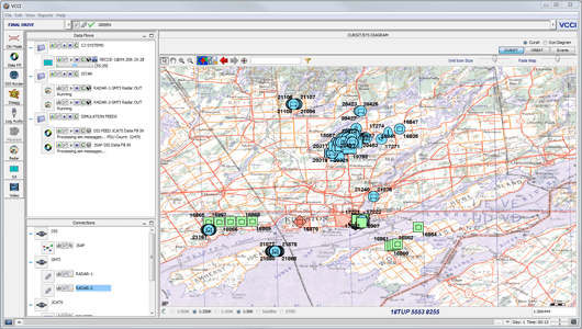
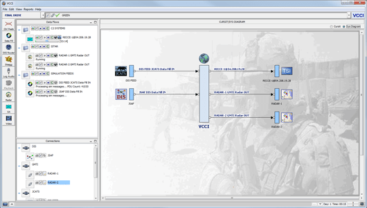
VCCI
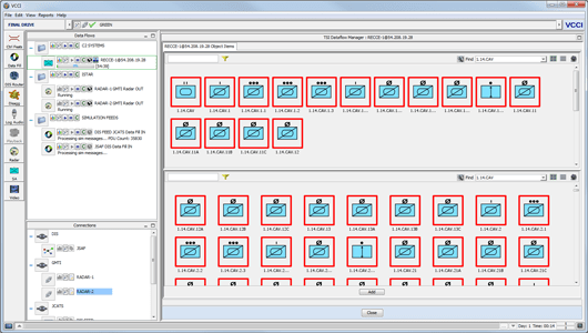
VCCI, the Virtual Command and Control Interface, is used to support simulation based training to the military. It is the middleware that sits between 3rd party simulators and military command and control applications. In broad terms, VCCI offers data translation, transformation and coordination services between 3rd party simulators and military command and control applications. It also provides value added simulation services in its own right.
More Information - VCCI

- Simulation data capture from a variety of simulators – examples:
ABACUS, JCATS, JSAF, all VBS versions. In addition to entity data VCCI offers a consolidated SIM record of each military event - CURSIT support via an embedded GIS engine enabling a common operating picture (COP) for all involved systems
- ORBAT support allowing users to work with simulation and C2 entities in the correct force organization
- After action review (AAR) functionality that enables users to leverage military event data captures to extract lessons learned
- Simulator control and monitoring which allows VCCI to interact with the simulations to the level which the simulations allow
- Command and Control system (C2) data fill and stimulation services enabling C2 entity locations, statuses and holdings to be updated in real time in a controlled fashion
- Data flow control to allow users to customize inbound and outbound data feeds in order to match exercise tempo and expected level of exercise fidelity
- Detailed mapping and routing at the entity level allowing for proper synchronization of SIM and C2 disparate entities
- C2 control feature collection allowing the retrieval of control features defined in the C2 system
- C2 control feature transfer to SIMs which avoids simulation controllers from having to manually enter the same data in the SIM(s) that has been entered into the C2 system
- Support for numerous military protocol standards including STANAG 4607 (GMTI), STANAG 4609 (Video), 4586 (UAV Control), STANAG 1287 (DIS), OTH Gold, Link 16
- Embedded DIS routing for optimum exercise data management and control
- Multiple distributed user interface support for diverse exercise and training floor layouts
- Actual value added simulation capabilities in order to cover shortfalls that may exist in the simulations used or to address specific Canadian military training or exercise requirements including:
- A) Enhanced radar model support allowing for the generation of radar detections
- B) Disaggregation of aggregate simulation objects which allows the objects to be decomposed to the entity level
ARAMIS
Aramis is a Military Off-The-Shelf (MOTS) After Action Review (AAR) tool that graphically represents complex simulation data captured from a military exercise. It allows the AAR analyst to quickly locate issues and specific topics from the exercise and display it in a meaningful fashion, thereby increasing the value of the event for the primary training audience. Because Aramis extracts its exercise data from NATO’s Multilateral Interoperability Protocol (MIP) Land Command and Control Information Exchange Data Model (LC2IEDM), it is simulation independent.

More Information - ARAMIS
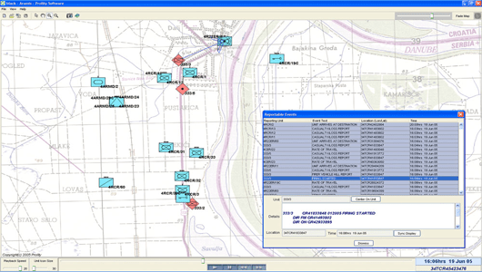
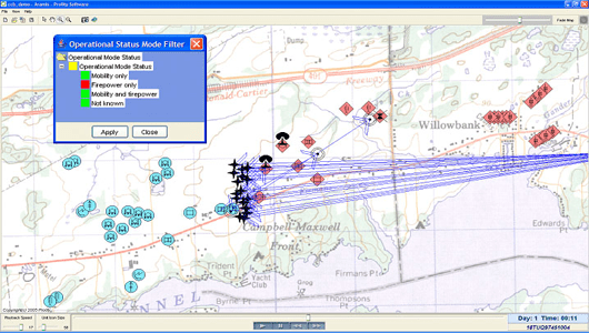 Aramis’ GIS functionality natively represents the source data provided by military mapping and charting establishments not tying the tool to any one particular simulation and presenting the picture as military commanders and their staffs are used to seeing it. The GIS functionality within Aramis allows the analyst to quickly locate strengths or weaknesses in the training audience’s terrain appreciation. Please contact us to get information on how Aramis can help you extract more benefit from the investment made in your existing simulation(s).
PARADIGM
Paradigm is a distributed component architecture which leverages the following architectural concepts, standards and best practices:
1) A Service Oriented approach to introducing and implementing capabilities (e.g. modelling and simulation capabilities).
2) An N-Tier architectural structure that maintains separation between presentation layers, business layers and resource layers.
3) A two tier Hub and Spoke interaction mechanism which allows data to flow between components using both a request / response model and a publish / subscribe model.

More Information - PARADIGM
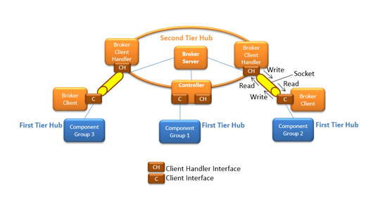 Paradigm is more than just a collection of architectural concepts, standards and best practices. It is a framework written in Java that can be run on any OS platform including Windows, Linux/UNIX and on mobile platforms if required.
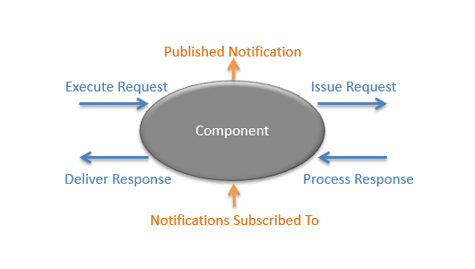 Runtime configurations can be defined to activate different combinations of components in one or more JVM (Java Virtual Machine) process. These processes can be distributed across different servers; the collection of which forms a running instance of a Paradigm based product (known as a system instance or syndicate).
SERR
More Information - SERR
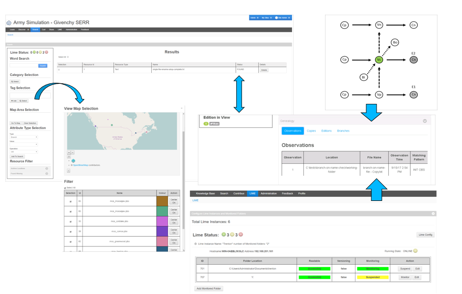
The application has two main parts, a web app and a Local Inventory Metadata Engine (LIME). The web app provides all administration, management and user functions such as tagging and searching. The LIME is a service that is co-located with the assets. LIME monitors the assets and abstracts the changes to the assets so that decision makerscan easily determine how many times an asset has been re-used, re-purposed or improved from its original purpose. SERR is a lightweight, simple to use tool for managing assets that are worked. While SERR was originally designed for the military modelling and simulation community, the application may be extended to commercial applications under its commercial name of DART (Digital Asset and Reference Trust).
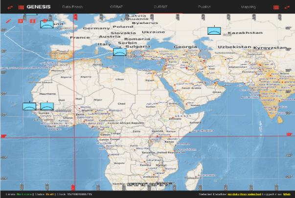
Genesis
- Simulation – C2 synchronization of data prior to exercise execution (Start State)
- Unit laydown, ORBAT, Control Feature support
- Collaborative web-based development of start state
- Provides permissions model for selective start state viewing/editing
- Data migration to all involved simulation and C2 applications
- GIS system supports OGC compliant map servers

More Information - Genesis
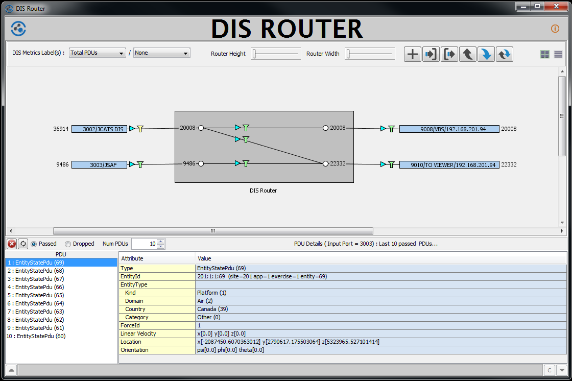
DIS Router
- Controls number and scope of DIS packets distributed to DIS enabled Simulation systems
- Provides standalone access to DIS Routing functions
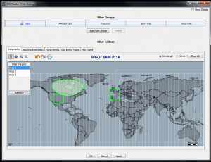
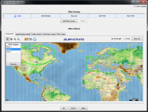
- Provides DIS flow control and full sieving and filtering of DIS packets
- Filters include PDU type, geographic, follow entity, entity type, app id, site id, exercise id, entity id
- Allows DIS routes to be merged, split, etc. for full control of PDU delivery
- Provides access to numerous DIS metrics
- Allows PDU interrogation for passed and/or dropped packets (due to filters)
- Provide unicast and multicast network support
More Information - DIS Router
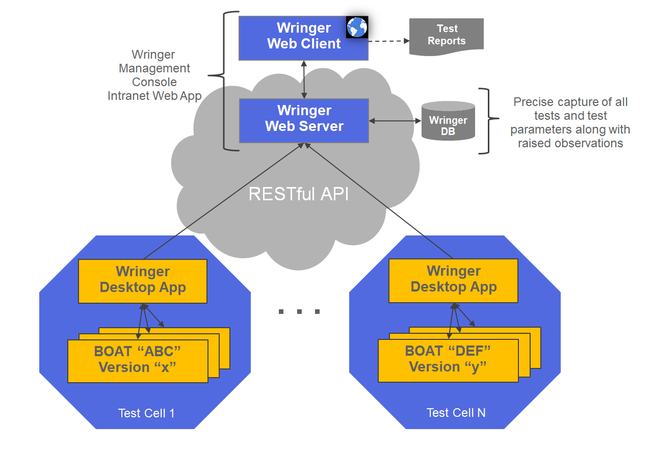
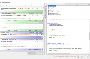
Wringer
- A multi-user system configuration, integration and testing solution
- Unique focus on confiurgation, integration and testing of C4ISR systems
- Supports Scaled Agile Framework (SAFe) continuous integration and DevOps
- Supports automated system configuration and, manual / automated testing including functional, regression, integration, system, stress, performance and user acceptance testing
- Uses the BDD (Behaviour-Driven Development) methodology to express test case specifications in an English-like language called Gherkin
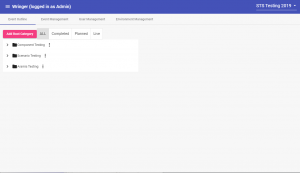
- Enables a team of testers to build test plans from well-defined building block test cases and coordinate / plan test executions
- Maintains a database of test cases, test plans, test execution results, testing parameters and observations raised to support repeatable testing
- Introduces a concept called Bring your Own Acceptance Tests (BOATs) that enables an OEM of a sub-system to combine their tests with other OEM providers of the same system to perform a complete System Of Systems test
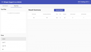
- Supports report generation for single test executions and for entire System Of System testing events
More Information - Wringer
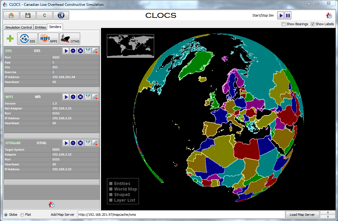
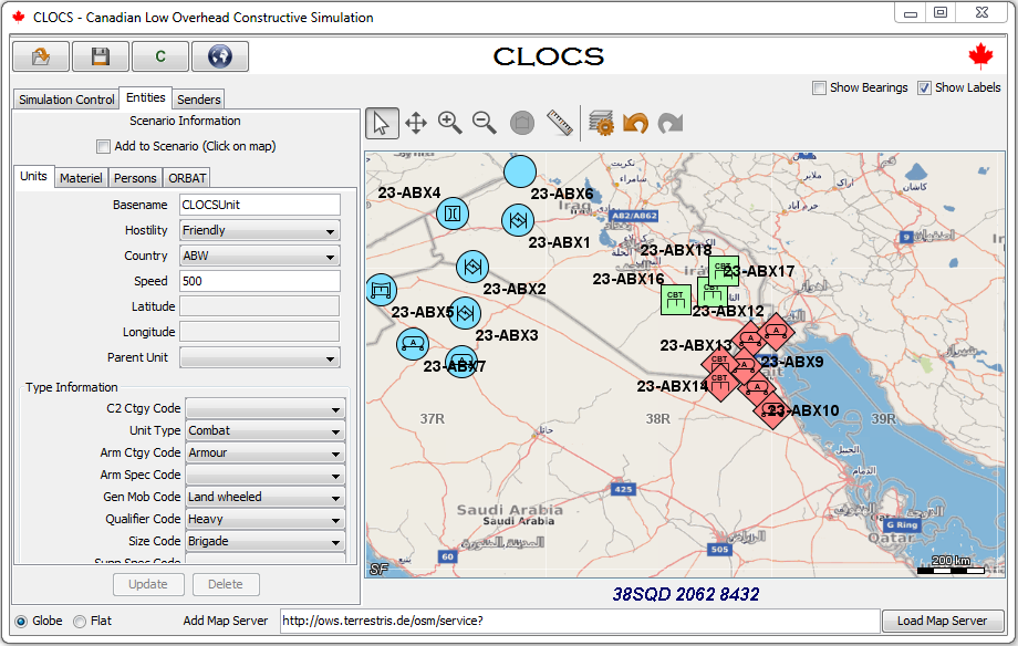
CLOCS (Canadian Low-Overhead Constructive Simulation)
- Provides a low overhead simulation capability
- Provides test interfaces to quickly exercise simulation/C2 interfaces for manual and automated testing
- Provides a simulation engine for entity movement along defined routes or in entity zones
- Supports the JC3IEDM data model for description of units, materiel and personnel
- Supports simulation/C2 protocols – DIS, NFFI, OTHGoldProvides JSON API for TCP-based application integration
- Configurable to use either Luciad or NASA World Wind for GIS operations
- Map interface supports OGC compliant map servers
- Provides scenario persistence
More Information - CLOCS
Map Spark
MapSpark is an Open Geo-Consortium Compliant (OGC) GIS service that will be used primarily in the Army vehicle-based systems and Synthetic Environment.
MapSpark is used to serve Geographical Information System (GIS) products to client applications.
MapSpark is a web-based server, where only one instance is required to support one site or one training event.
MapSpark has a small footprint and can also be deployed on laptops at the vehicle-level to support mobile GIS/map requirements.
- OGC Services Available WMS: Web Map Service: provides map images
- WMTS: Web Map Tile Service: providers map image tiles
- WFS: Web Feature Service: for retrieving or altering feature descriptions (2021)
- WCS: Web Coverage Service: provides access, subsetting, and processing on coverage objects (2021)
- Supported Map/GIS Data
- File based Imagery (GeoTiff, PNG, JPEG, JPG, JP2, ADRG, CADRG, NITF, NSF, CIB, ASRP, USRP)
- Tile sets (MBTile, Tile Package)
- Vector data (Shapefile, File Geodatabase, GeoPackage) (2021)
- Elevation (DTED2) (2021)
REST Endpoints Status, Version, Catalog, Administration

T4 ATC
T4 ATC is for organizations that need to train Air Traffic Control (ATC) Tower controllers to operate in highly unique ATC environments without using human role players. T4 ATC is a data driven system desktop training system that utilizes speech recognition to allow ATC trainees to independently practice pattern management and conflict resolution within the context of their own environment.
More Information - T4 ATC
Unlike other Tower ATC desktop simulations that use generic airfields and generic procedures that require ATC trainees to adapt to the simulation, T4 ATC was designed to reflect the specifics of an aerodrome thereby allowing the trainee to directly transfer learning from the simulation to the real-world.
This results in higher trainee confidence and competence, which in turn results in greater rates of first time right performance when working with live traffic. T4 ATC was first designed and built for the Canadian Military ATC community. Six sites across Canada will take delivery of T4 ATC systems
T4 WATCH
